Contributed by Maine Historical Society

- Item 11715
- print page
- download web image
Purchase a reproduction of this item on VintageMaineImages.com.
Description
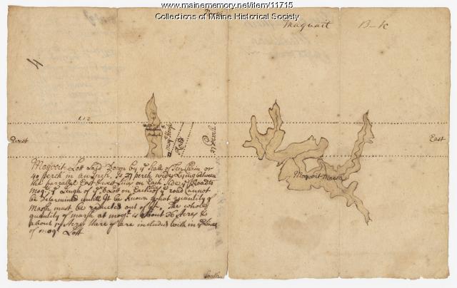
Manuscript map #4 of a plan of Maquoit Meadows, ca. 1720. Map commissioned by the Pejepscot Purchase Company and surveyed by Col. Joseph Heath. The verso of the map lists the names of each lot owner.
Transcription
About This Item
- Title: Plan of Maquoit Meadows, ca. 1720
- Creator: Joseph Heath
- Creation Date: circa 1720
- Subject Date: circa 1720
- Location: Brunswick, Cumberland County, ME
- Media: Ink on paper
- Dimensions: 31 cm x 19 cm
- Local Code: Coll. 61, Map 4
- Collection: Pejepscot Proprietors papers
- Object Type: Text and Image
Cross Reference Searches
Standardized Subject Headings
- Brunswick (Me.)--Maps--Early works to 1800
- Land companies--Maine
- Land grants--Maine--Maps
- Land settlement--Maine
- Maine--History--Colonial period, ca. 1600-1775--Maps--Early works to 1800
- Maine--Maps--Early works to 1800
- Manuscript maps
- Maquoit Meadows (Brunswick, Me.)--Maps--Early works to 1800
- Pejepscot Company--Records and correspondence
- Real property--Maine--Brunswick
People
For more information about this item, contact:
Maine Historical Society485 Congress Street, Portland, ME 04101
(207) 774-1822 x230
Website
Use of this Item is not restricted by copyright and/or related rights, but the holding organization is contractually obligated to limit use. For more information, please contact the contributing organization. However, watermarked Maine Memory Network images may be used for educational purposes.
Please post your comment below to share with others. If you'd like to privately share a comment or correction with MMN staff, please send us a message with this link.
