

Indian Raid on Casco Bay, 1676
Maine Historical Society
At a conference in Pemaquid in 1676 English officials gained an uneasy armistice that lasted until several Indians were kidnapped nearby and carried off as slaves. Indians insisted on powder and shot, and English negotiators refused, demanding that the Abenaki admit blame for the war and join in attacking other hostile tribes.
That summer Abenaki and their allies, including Micmacs and remnants from King Philips' troops, attacked settlements eastward to Cushnoc on the Kennebec, moving from cabin to cabin in swift raid-and-retreat maneuvers. In August the well-established trading post at Arrowsic fell in hand-to-hand combat, and the fort, mills, mansion house, and outbuildings were burned.
Later that fall the Pemaquid settlement was destroyed as Indians cut off access to the neck of land separating men in the fields and fishing boats from women and children in the village. With no alternative but to return to their homes, the men regained the fortress, but many were killed or taken prisoner.
Settlers fled to the nearby islands and watched as the "whole circle of the horizon landward was darkened and illuminated by the columns of smoke and fire rising from the burning houses of the neighboring Main." After a month, they sailed south. In the course of five weeks, 60 miles of coast east of Casco Bay had been wiped clean of English settlements.

Garrison Cove Marker on Black Point Road in Scarborough, 1676
Scarborough Historical Society & Museum
Hardships were equally severe on the Abenaki side. Families fled their villages, leaving fields unharvested. Denied access to their guns, ammunition and fishing grounds, many starved.
Despite overtures for peace on both sides, seafaring slavers continued to murder and kidnap along the coast, and in September 1676 Major Richard Waldron invited 400 Indians to a conference at Dover, New Hampshire, and used the occasion to enslave around 200.
In February Waldron led an expedition eastward to ransom English captives and capture Madockawando. Although he failed on both accounts, he managed to kill eight peace-seeking Indians at Pemaquid.
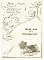
Black Point, Scarborough, ca. 1633 - 1728
Maine Historical Society
In 1678 the provincial government of New York, which controlled Maine between 1677 and 1686, signed the Treaty of Casco. According to its terms, the Abenaki recognized English property rights but retained sovereignty over Maine, symbolized by an annual land use tax for every English family. The treaty also stipulated closer government regulation of the fur trade.
In 1686 Sir Edmund Andros, appointed governor of the Dominion of New England, took charge of Indian relations. Although widely resented as a representative of the Catholic King Charles, Andros acted decisively to regulate the fur trade in a manner that would ensure fair prices and protect native clients from abuses. Pemaquid was designated the sole trading post between the Kennebec and Penobscot rivers, and ammunition was traded only in amounts deemed necessary for hunting.
Despite fresh memories of a horrible conflict, settlers refused to abide by the terms of the Treaty of Casco. Traders continued unfair practices, settlers placed nets across the Saco River, preventing fish from migrating upriver to the Wabanaki villages, and livestock ruined Indian corn. Negotiations and further treaty attempts were not successful and confrontations continued.

Baron St. Castin (1650-1712), ca. 1670
Maine Historical Society
King William's War
During King William's War (1689-1699), Comte de Frontenac, the aggressive governor general of New France, launched a campaign to conquer all of North America. A large force of French and Indians drove the English from the settlements east of Falmouth. Baron de St. Castin, who lived with his family in a village of 160 Etchemin Indians on the Bagadauce River near present-day Castine, became a target for militia raids, and he helped launch a series of attacks on Maine settlements in the summer of 1689.
The major event of the war came in September 1689 when 200 Norridgewock, Penobscot, and Canada Indians converged on Peaks Island In Casco Bay and, on September 20, attacked the Back Cove settlements. Major Benjamin Church arrived by sloop at sunrise at Fort Loyal, and after a "fierce fight" drove the Indians from the area.

Old Fort at Pemaquid Beach, ca. 1900
Maine Historical Society
Exhausted by war and discouraged by French ambivalence, in 1693 the Abenaki sued for peace, but the English refused to negotiate on realistic terms. This brought another round of attacks on English settlements in 1694.
The English at Fort William Henry, built under the authority of Governor Sir William Phips in 1692 at a huge cost, fell to a force of Canadian-based Abenaki in August 1696, and the English once again abandoned the lower Kennebec. Massachusetts counterattacks against Port Royal and Quebec were largely ineffectual, as were several raids up the Kennebec and Penobscot rivers.
France and England concluded a peace in 1697, and in 1699 the Wabanaki agreed to a treaty. In 1698 Father Sebastien Rasle (also spelled Rale or Rasles) built a mission at the Indian village in Norridgewock on the upper Kennebec River, and this became a center for French-Indian interaction. With the coast east of Wells nearly devoid of English settlers, Rasle's mission became the southern boundary of New France.


