LC Subject Heading: Maps
- Historical Items (600)
- Tax Records (0)
- Architecture & Landscape (1)
- Online Exhibits (0)
- Site Pages (0)
- My Maine Stories (0)
- Lesson Plans (0)
Historical Items
These results include photographs, documents, letters, paintings, artifacts, and many other kinds of Maine related items from collections around the state and elsewhere.
Item 9261

Contributed by: Maine Historical Society Date: 1814 Media: Pencil and ink
Item 4177

Contributed by: Maine Historical Society Date: circa 1801 Media: Paper
Item 105273

Map of the State of Maine, 1861
Contributed by: Osher Map Library and Smith Center for Cartographic Education Date: 1861 Media: Lithograph
Item 105355

Contributed by: Osher Map Library and Smith Center for Cartographic Education Date: 1824 Media: Engraving
Item 18717

Map of the City of Portland, 1836
Contributed by: Maine Historical Society Date: 1836 Location: Portland Media: Ink on paper
Item 22212

Contributed by: Aroostook County Historical and Art Museum Date: circa 1870 Location: Houlton Media: Ink on paper
Item 105360

Contributed by: Osher Map Library and Smith Center for Cartographic Education Date: 1855 Media: Lithograph
Item 4174

Map of Portland and vicinity, 1900
Contributed by: Maine Historical Society Date: 1900 Location: Portland Media: Paper
Item 4175

Plan of the City of Portland, 1837
Contributed by: Maine Historical Society Date: 1837 Location: Portland Media: Paper
Item 105318

Map of the town of Camden, 1875
Contributed by: Osher Map Library and Smith Center for Cartographic Education Date: 1875 Location: Camden; Rockland Media: Lithograph
Item 9539

Railroad map of northern New England and the Maritime Provinces, 1882
Contributed by: Maine Historical Society Date: 1882 Media: Ink on paper
Item 22213

Contributed by: Aroostook County Historical and Art Museum Date: circa 1870 Location: Mechanic Falls Media: Print
Item 22699

Contributed by: Maine Historical Society Date: circa 1875 Location: Portland Media: Lantern slide
Item 26674

Map of Cobscook Bay Area, 1881
Contributed by: Lubec Historical Society through Lubec Memorial Library Date: 1881 Media: Photo negative
Item 30213

Contributed by: Prince Memorial Library Date: 1857 Location: Cumberland Media: Wall map, ink on paper
Item 35622

Contributed by: Maine Historical Society Date: 1871 Location: Lovell Media: Ink on paper
Item 59765
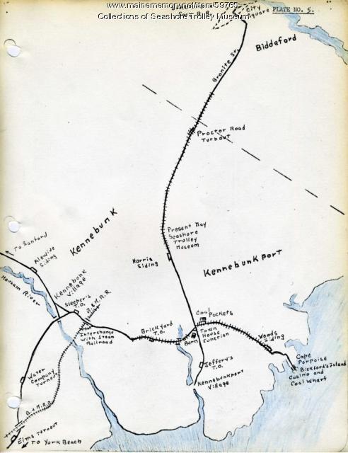
Kennebunk Village to Cape Porpoise electric railroads, ca. 1927
Contributed by: Seashore Trolley Museum Date: circa 1927 Location: Kennebunk; Cape Porpoise Media: Ink on paper
Item 105266

Contributed by: Osher Map Library and Smith Center for Cartographic Education Date: 1859 Media: Lithograph
Item 105310

Birds eye view showing Portland Railroad System and connecting lines, 1909
Contributed by: Osher Map Library and Smith Center for Cartographic Education Date: 1909 Location: Saco; Portland; Portland; Old Orchard Beach; South Portland; Cape Elizabeth Media: Lithograph
Item 105630

Contributed by: Maine Historical Society Date: 1835 Media: Ink on paper
Item 4168

Contributed by: Maine Historical Society Date: 1690 Location: Portland Media: Ink on paper
Item 6894

Plan of the Kennebec Million Acres, 1823
Contributed by: Maine Historical Society Date: 1823-10-17 Location: Kingfield; Moscow Media: Ink on paper
Item 10684
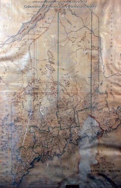
Contributed by: Salmon Brook Historical Society Date: circa 1825 Media: Digital photograph of printed map
Item 11043

Waterfront and downtown Bath, 1851
Contributed by: Patten Free Library Date: 1851 Location: Bath Media: Ink on paper
