Keywords: Levies
Item 10432

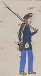
Levi W. Smith, Vinalhaven, 1880
Contributed by: Maine Historical Society Date: 1880 Location: Vinalhaven; Vinalhaven Media: Photoprint
Item 27840

Lime Quarry, Thomaston, ca. 1870
Contributed by: Thomaston Historical Society Date: circa 1870 Location: Thomaston Media: Photographic print

Item 85670

Levy property, W. side Island Avenue, Peaks Island, Portland, 1924
Owner in 1924: Sarah Levy Use: Summer Dwelling
Item 42590

160-166 Cumberland Avenue, Portland, 1924
Owner in 1924: Benjamin Levi Use: Apartments

Item 111476

Levi residence floor plan, Freeport, 1983
Contributed by: Maine Historical Society Date: 1983 Location: Freeport Client: Levi Architect: Carol A. Wilson; R.E. Wengren Associates, Architects
Item 110483

White-Levy residence architecture, Lewisboro, NY, 1994-1995
Contributed by: Maine Historical Society Date: 1994–1995 Location: Lewisboro Client: Leon Levy Architect: Nile, Inc.

Exhibit

John Hancock's Relation to Maine
The president of the Continental Congress and the Declaration's most notable signatory, John Hancock, has ties to Maine through politics, and commercial businesses, substantial property, vacations, and family.
Exhibit

Colonial Cartography: The Plymouth Company Maps
The Plymouth Company (1749-1816) managed one of the very early land grants in Maine along the Kennebec River. The maps from the Plymouth Company's collection of records constitute some of the earliest cartographic works of colonial America.

Site Page

John Martin: Expert Observer - Intro: pages 604-650
"Wiggin Levi B. Murch Nath Harlow Charles Sawtell Mary Harkness Ada Martin Annie Martin Junior Martin Elmer Martin Bangor High School Division Street…"
Site Page
John Martin: Expert Observer - Part 7, pages 114-134
"Wiggin Levi Burch James Dean Edward Getchell O. H. Ingalls William Severance Fuller Orff Henry Holden Willington Farm Barracks Col."

