Contributed by Maine Historical Society

- Item 11929
- print page
- download web image
Purchase a reproduction of this item on VintageMaineImages.com.
Description
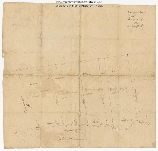
Manuscript map #66 of Flying Point at Maquoit Bay in Freeport. The map was commissioned by the Proprietors of the Township of Brunswick, also known as the Pejepscot Proprietors, which was a large land company formed in Massachusetts to colonize present-day Maine. The company was comprised of some of the most politically influential and wealthy merchants in New England.
About This Item
- Title: Flying Point at Maquoit Bay, Freeport, ca. 1770
- Creator: Proprietors of the Township of Brunswick
- Creation Date: circa 1770
- Subject Date: circa 1770
-
Locations:
- Freeport, Cumberland County, ME
- Brunswick, Cumberland County, ME
- Media: Ink on paper
- Dimensions: 29 cm x 30 cm
- Local Code: Coll. 61, Map 66
- Collection: Pejepscot Proprietors papers
- Object Type: Text and Image
Cross Reference Searches
Standardized Subject Headings
- Freeport (Me.)--Maps
- Land companies
- Land grants--Maine
- Land settlement--Maine--Freeport
- Maine--History--Colonial period, ca. 1600-1775--Maps, Manuscript--Early works to 1800
- Pejepscot Company--Records and correspondence--Maps, Manuscript--Early works to 1800
- Real property--Maine--Freeport
People
Other Keywords
For more information about this item, contact:
Maine Historical Society485 Congress Street, Portland, ME 04101
(207) 774-1822 x230
Website
Use of this Item is not restricted by copyright and/or related rights, but the holding organization is contractually obligated to limit use. For more information, please contact the contributing organization. However, watermarked Maine Memory Network images may be used for educational purposes.
Please post your comment below to share with others. If you'd like to privately share a comment or correction with MMN staff, please send us a message with this link.
