Contributed by Maine Historical Society

- Item 4323
- print page
- download web image
Purchase a reproduction of this item on VintageMaineImages.com.
Description
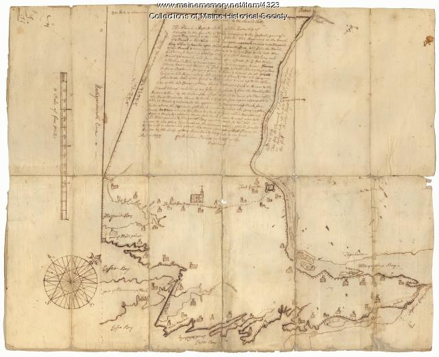
A group of eight men from Boston formed the Pejepscot Proprietors land company in 1714 when they acquired Richard Wharton's land parcels including the towns now known as Brunswick, Topsham, Harpswell, and Lewiston. The Proprietors promoted settlement and sold the land at a profit for the benefit of shareholders.
This 1738 map of the area around Brunswick was commissioned by the Pejepscot Proprietors. The area is bounded on the northeast by the Androscoggin River and Merrymeeting Bay, and on the northwest by Bunganuc Creek, the former North Yarmouth town line.
This map is marked #7. Scale [1:31,680] 160 rods = 1 inch.
About This Item
- Title: "Scituate," Brunswick, 1738
- Creator: Belcher Noyes
- Creation Date: 1738
- Subject Date: 1738
-
Locations:
- Brunswick, Cumberland County, ME
- Harpswell, Cumberland County, ME
- Topsham, Sagadahoc County, ME
- Media: Ink on paper
- Dimensions: 47 cm x 58 cm
- Local Code: Coll. 61, Map 7
- Collection: Pejepscot Proprietors papers
- Object Type: Text and Image
Cross Reference Searches
Standardized Subject Headings
- Androscoggin River (N.H. and Me.)--Maps--Early works to 1800
- Brunswick (Me.)--Maps--Early works to 1800
- Land companies--Maine--Maps
- Land grants--Maine--Maps
- Land settlement--Maine--Maps
- Maine--History--Colonial period, ca. 1600-1775--Maps--Early works to 1800
- Manuscript maps
- Pejepscot Company--Maps--Early works to 1800
- Real property--Maine--Maps
People
Other Keywords
- Androscoggin River
- Brunswick
- Bungamunganock
- Bunganuc
- Casco Bay
- Early contact & settlement
- Fort George
- Maps, Early.
- Maps, Manuscript.
- Maquoit
- Mere Point
- Merriconeag Neck
- Merrymeeting Bay
- Nature, geography & animals
- Pejebscot Proprietors
- Pejepscot Proprietors
- Personal writing to 1800.
For more information about this item, contact:
Maine Historical Society485 Congress Street, Portland, ME 04101
(207) 774-1822 x230
Website
Use of this Item is not restricted by copyright and/or related rights, but the holding organization is contractually obligated to limit use. For more information, please contact the contributing organization. However, watermarked Maine Memory Network images may be used for educational purposes.
Please post your comment below to share with others. If you'd like to privately share a comment or correction with MMN staff, please send us a message with this link.
