Contributed by Maine Historical Society

- Item 12197
- print page
- download web image
Purchase a reproduction of this item on VintageMaineImages.com.
Description
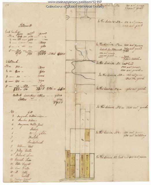
Manuscript map 18 used by the commissioners (Plymouth Company) in the division of the Tyng and Lowell Estates, Plymouth Company records.
About This Item
- Title: Division of the Tyng and Lowell estates, ca. 1760
- Creator: Plymouth Company
- Creation Date: circa 1760
- Subject Date: circa 1760
-
Locations:
- Kennebec County, ME
- Kennebec County, ME
- Media: Ink on paper
- Dimensions: 38 cm x 31 cm
- Local Code: Coll. 60, Map 18
- Collection: Plymouth Company (1749-1816) records
- Object Type: Text and Image
Cross Reference Searches
Standardized Subject Headings
- Kennebec patent
- Land grants--Maine
- Landowners--Maine
- Maine--History--Colonial period, ca. 1600-1775--Maps--Early works to 1800
- Manuscript maps
- Plymouth Company (1749-1816)--Records and correspondence--Maps--Early works to 1800
People
For more information about this item, contact:
Maine Historical Society485 Congress Street, Portland, ME 04101
(207) 774-1822 x230
Website
Use of this Item is not restricted by copyright and/or related rights, but the holding organization is contractually obligated to limit use. For more information, please contact the contributing organization. However, watermarked Maine Memory Network images may be used for educational purposes.
Please post your comment below to share with others. If you'd like to privately share a comment or correction with MMN staff, please send us a message with this link.
