Contributed by Maine Historical Society

Description
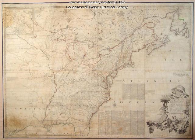
Englishman John Mitchell's monumental map demonstrates how British and French governments attempted to use European laws to control Indigenous Homelands. The effects of settler colonialism are visualized here, like a snapshot in time. The land that had been affected by colonization since the 1600s show English and French place names imposed on Native territories, especially along the coast of what is now Maine and Massachusetts.
Areas further west retain Native names—and the mystery of the unknown and what the European Imperialist mind viewed as "empty spaces." Notes on the map describe how the land might be used for profit, the natural resources and potential for settlement of frontier regions. Some describe the Tribes and show ancient Native routes.
This map is dated 1775 but is the seventh version of the original, which was printed in 1755. The Library of Congress's Geography and Map Division called Mitchell's map "the most important map in American history."
About This Item
- Title: Map of the British and French North America, 1775
- Creator: John Mitchell
- Creation Date: 1775
- Subject Date: 1755
-
Locations:
- USA
- Canada
- Media: Ink on paper, map
- Dimensions: 136 cm x 195 cm
- Local Code: Map R 6
- Object Type: Text and Image
Cross Reference Searches
Standardized Subject Headings
- British--America--Maps--Early works to 1800
- Great Britain. Treaties, etc. United States, 1783 Sept. 3
- North America--Maps--Early works to 1800
- Northeast boundary of the United States--Maps--Early works to 1800
Other Keywords
For more information about this item, contact:
Maine Historical Society485 Congress Street, Portland, ME 04101
(207) 774-1822 x230
Website
Use of this Item is not restricted by copyright and/or related rights, but the holding organization is contractually obligated to limit use. For more information, please contact the contributing organization. However, watermarked Maine Memory Network images may be used for educational purposes.
Please post your comment below to share with others. If you'd like to privately share a comment or correction with MMN staff, please send us a message with this link.
